 rus
rus
 eng
eng
Charts system Olex Lino
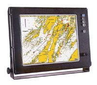
Lino - is the electronic chart system for any type of the vessel of any area of fishing. System is easy to use and shows maximum possibilities of chart mapping.
Quick access and a work with any part of chart, which shows a high clearness of, reflected details. Instant chart scaling. Usage of official electronic charts, which have proven itselves on many vessels of worldwide marine fleet.
Easy routing, automatic saving of all accomplished routes, transformation of all motion paths into autopilot route. Unlimited capacity of plotter saved data.
Technical specifications
| Parameters, function | Values |
| Marine chart system: Norwegian drainage service C-MAP charts Official electronic charts |
S57 and NSKV format СМ93 format IC-ENC, NOAA, Primar Stavanger, ChartWorld |
| Electronic chart managing | With a help of keyboard and mouse |
| Modes of bottom reflection | 2D map - flat reflection 3D map - volume reflection |
| Registration and record of water temperature | From - 5° to + 30° С |
| Modes of transferring data to autopilot | According to track spots According to route |
| Direction of chart orientation | Any |
| Consideration of undercurrent influence | Automatic |
| Connecting of outward equipment | Autopilot,GPS, Echosounder, Gyro, Radar Compass, temperature sensor, AIS |
| Additional functions and opportunities | Bottom solidity determination 3D views presentation and trawl positioning (ITI) |
| Highlighting of objects on a chart | Animated lights and sectors |
| Color marking of bottom solidity | From brightly rose (mild bottom) Till brightly yellow (solid bottom) |
| Manu language | English, German, French, Norwegian, Spanish |
| Display requirements | Resolution not less than 1024 х 768 pixels, 70 Hz |
A scope of delivery
- Display;
- A set of mounting tools.